|
|
|
|
|
|
|
|
|
|
|
|
|
|
|
|
|
|
|
|
|
|
|
|
|
|
|
|
|
|
|
|
|
|
|
|
|
|
|
|
Below are a variety of distribution Maps for the Medieval Fortifications of England and Wales. Clicking on the map links to a larger version of the map. Please feel free to download these for your own use. The maps are derived from my database and only include the possible and certain sites in that database. New maps will be added from time to time.
Distribution maps can be a particularly difficult resource to properly understand. Random distribution are not even and it is the nature of human psychology to see patterns in random distributions. Any serious study based on conclusions about distributions should probably be checked and analyzed by a statistician.
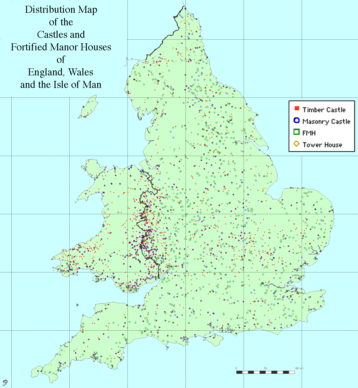 This
map adds a little to previous castle distribution maps, most notable the one
prepared by Derek Renn which covered the whole British Isles. The addition
of Fortified Manor Houses does seem to extend and deepen the Welsh March into
Staffordshire and Worcestershire and fill in some of the 'gaps' in Norfolk
although this remains a county of remarkable low density of castles. Lancashire
is also a county with a low density. The classic band of castles along the
England/Wales boundary clearly shows, but this may be to a large number of small isolated mounds which, whilst described as mottes, are quite different from the textbook motte and bailey castle (see comments regarding the early castles map.)
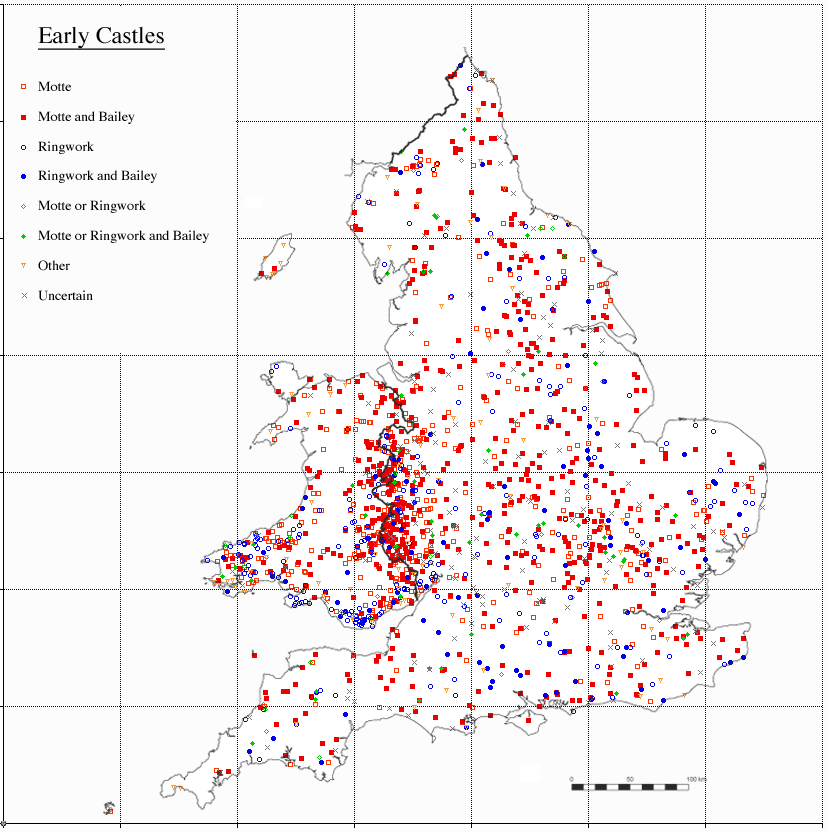
A map of early castles, those known or suspected to have been constructed before 1150 (or 1200 in Wales). The map shows the castles by their earliest form. All are as site is recorded to have been. The site may or may not have any remains.
The difference between a ringwork, a ringmotte (a ringwork with a raised inner platform) and the many forms of mottes (particularly the common low mound) is a matter of some discussion, debate and difference of opinion. It should also be noted that mounds which have been damaged by excavations, erosion or otherwise, and particularly mounds which had masonry buildings which have collapsed or been robbed out may have a form very different to how the originally looked. (A motte around a wooden tower which has since rotted away may well have a depressed centre making the mound look like a small ringwork. A collapsed gatehouse on the edge of a ringwork may be so covered with earth as to look like a motte. etc.)
Because of damage to mounds ringworks and ring-mottes are probably under reported and several reported 'mottes' were probable ringmottes. Castle vary greatly in form and overlap between any classification of castle forms is certain to happen. Take Oakham Castle were the square enclosure with massive earth ramparts has had one corner heightened and enlarged to form a motte. This is called a motte and bailey, although the motte does not seem to have been particularly strong and the whole clearly has much more in common with a large ringwork like Castle Rising.
The distribution must be taken with much care, the large concentration in the marches is made up of some major castles and a great number of very small mottes many of which could not have had any military function and which probably had very little administrative role. In this area I suspect local manor houses, held by knight's for feudal service, had what were fundamentally symbolic mounds built by them to establish a concept of Norman dominion in an area where even English dominion had been under question. If these minor 'knight's fee' mounds were to be removed from the map the national distribution map would be more even.
In the key 'Motte or Ringwork' are earthwork recorded as either motte or ringwork (Sometimes the earthwork is so mutilated as to be uncertain to individual making the report otherwise different reports described the site as either a motte or a ringwork). Also includes those earthworks that have been altered from one form to another as at Goltho; 'other' are castles of a form other than Motte or ringworks - These can reused earlier fortified sites or ditched enclosures without significant embankments such as Clavering Castle or sites of natural strength such as Bamburgh Castle (But where an earlier fortification is adapted into a bailey this will be recorded above - i.e. Burgh Castle where a motte is built in a Roman shore fort is recorded as a motte and bailey); 'Uncertain' are lost site known from historical records but who's form is uncertain or very damaged sites were the form is uncertain.
The map shows the concentration of Ringworks in South Glamorgan, for which a interesting and convincing theory is put forward by Jack Spurgeon that this is due to underlying soil conditions (Spurgeon, C.J., 1987. 'The castles of Glamorgan: some sites and theories of general interest' Chateau Gaillard Vol. 13 pp. 203-26). Another concentration of ringworks exist in Hampshire but generally the distribution seems fairly random.
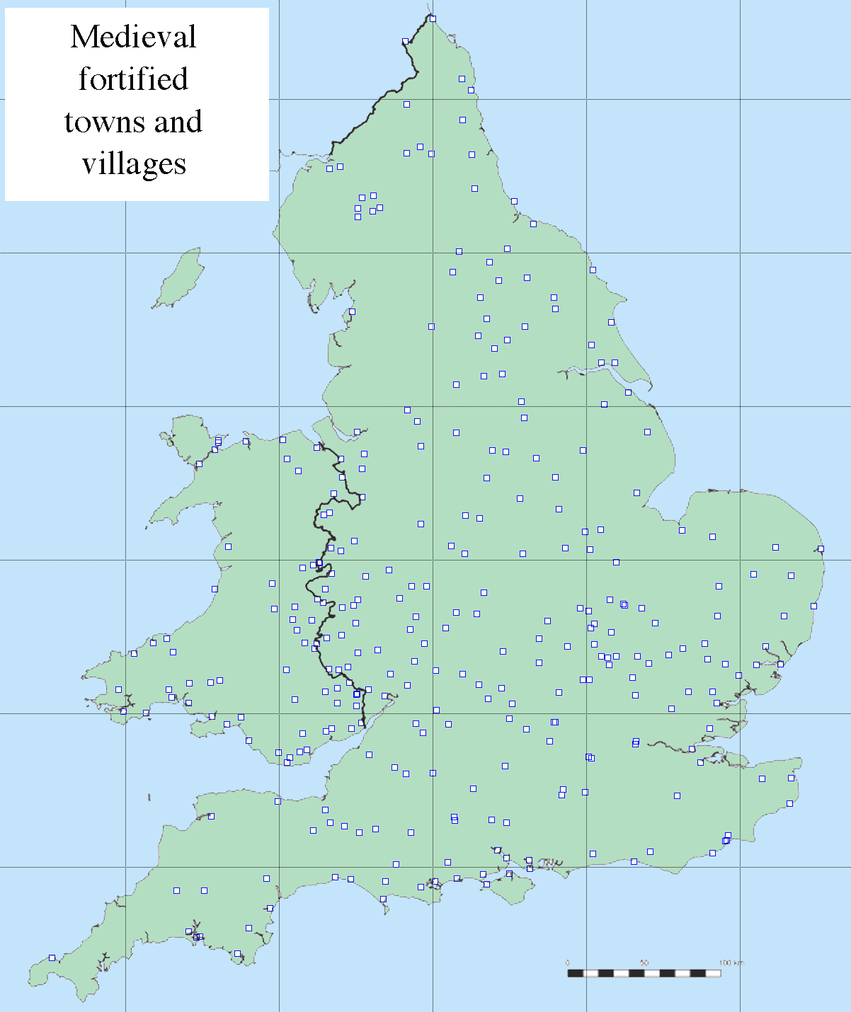 This map includes defended villages and a cluster of such villages near Penrith
in Cumbria can clearly be seen. Generally distribution is even with poor
areas (i.e. Lancashire) and highland and fenland areas which are clear of any
major urban areas showing fairly clearly. There is some evidence of a band of
fortified towns along the Welsh border; these are nearly all small burgus enclosures
associated with castles and represent, often failed, attempts to found towns
in the 12th and 13th centuries. The band of clear area around London probably
shows the economic dominance of London and it's effect on preventing the development
of large towns near to London rather than any conscious demilitarised zone.
 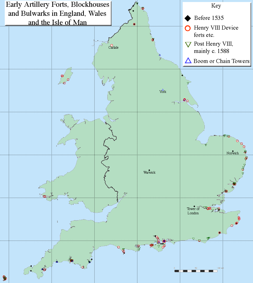 These are
mainly coastal fortifications general built to deter landings and raids on
harbours from foreign shipping. The earlier fortifications tend to be private
enterprises against small raids and pirates. The major scheme by Henry VIII
in the 1540's and more hurried defenses by Elizabeth in 1588 defended against
feared european invasion. The few, non coastal, exceptions are number of works,
such as Carlisle and Norham,
built to defend the Scottish border; the additions of some bulwarks to the Tower
of London; the Cow Tower in Norwich,
part of the town defences and the, never finished, rectangular artillery tower
by Richard III at Warwick Castle. A number
of harbours were fitted with chains across the entrance, usually managed from
defended chain, or boom, towers. York had
such a chain across the Ouse but this, as with the coastal port towns, was probably more concerned with control
of trade.
 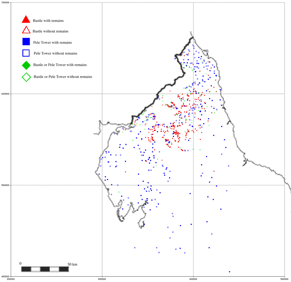 The Monuments Protection Programme definition of a bastle is; “a two-storeyed,
roughly built, defensible farmhouse with the main living area on the first floor
and storerooms or an animal shelter below. Bastles are characterized by their
thick walls, small doorways and narrow slit-windows on the ground floor. They
are found only in northern England along the Scottish Border. Bastles were defensible
farmhouses providing protection for both the human and the animal populations.” To
this can be added that ground plan is rectangular. Bastles start
to appear in the sixteenth century and are built into the eighteenth century.
Bastles were clearly a response to the endemic cattle raiding in the area. The
best preserved example is Black Middens, which is in
the care of English Heritage and readily open to the public. For the purpose
of this map pele towers are the smaller tower-houses of non-manorial status,
often the residence of vicars. They are included because the remains and historical
records can be confused with bastles; pele towers date from the thirteenth to
fifteenth centuries.
The concentration of bastles in the high moors contrasts with the more even distribution of pele towers (although the highest land is empty of all building). The scale of the map means some dots mark groups of bastles; Evistone and Chesterwood were examples of groups of bastles forming defensible hamlets.
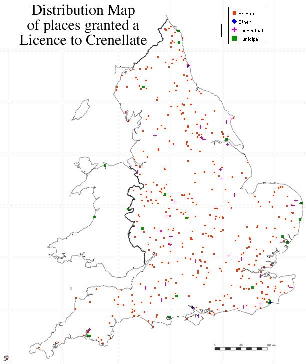 For a full discussion of licences to crenellate see the list and analysis.
The distribution map shows little other than the tendency for municipal licences
granted to build town walls to be mainly a feature of coastal towns. Distribution
is generally random (although with a notable cluster around London) and there is certainly no evidence of a concentration of licenced
'fortifications' in the Scottish March or the coast.
 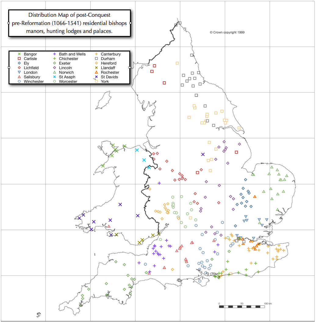 Generally bishops houses were distributed around there respective bishoprics (or sees) however there are some exception with some northern bishops having houses outside their see given a base for trips to Westminster. All bishoprics (except tiny St Asaph) had a town house in or near the city of London although at this scale this is unclear.
 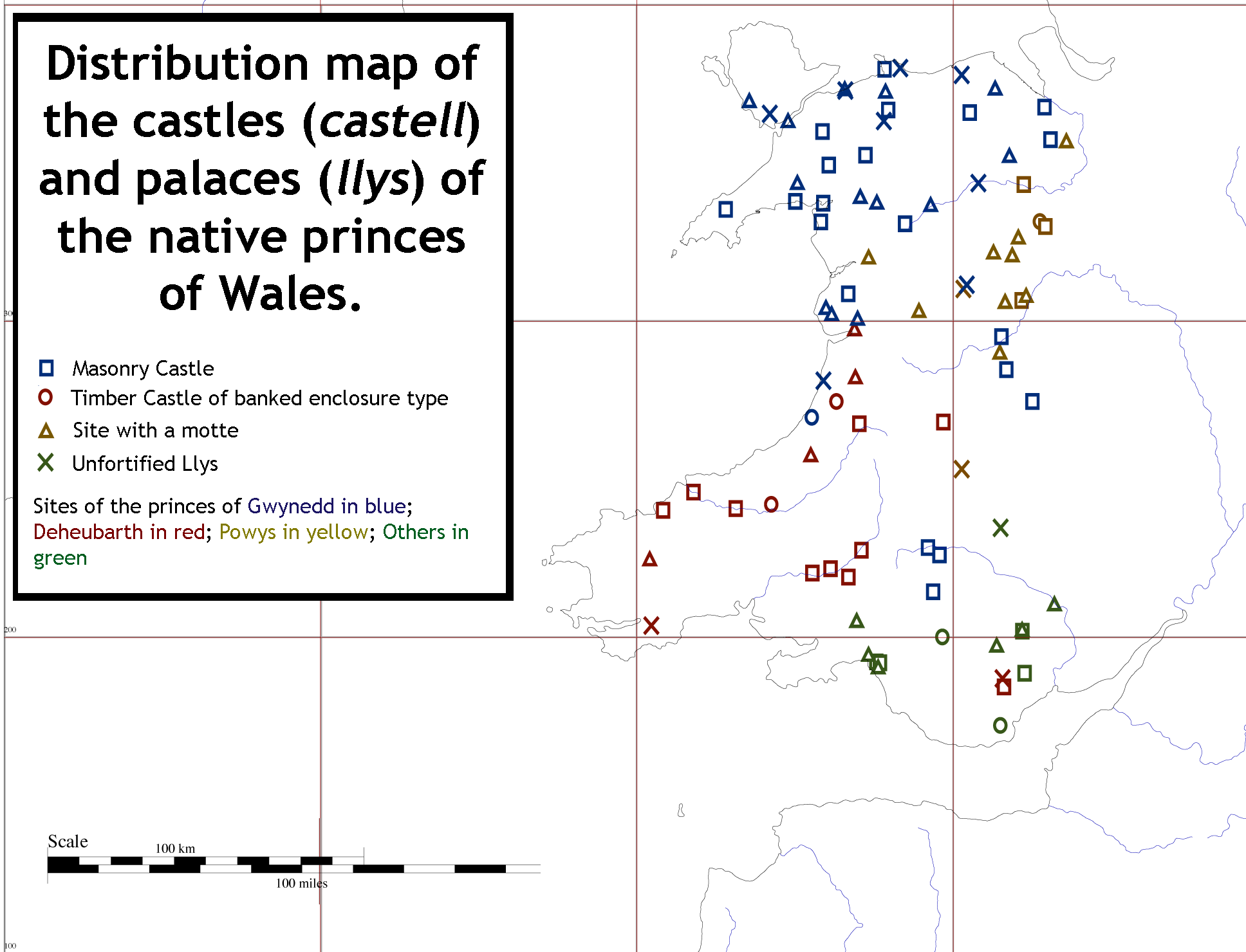 Further Information on the castles of the native welsh princes can be found in