DescriptionSolitary bastle, 10.9m long x 6.4m wide. End wall 1.2m thick. Byre door in gable wall (Ryder 1986)
Whitlow Tower or Castle, ruins noted by John Warburton in c.1715. (Possibly NY 64 NE 10 or 11?) (Long 1967).
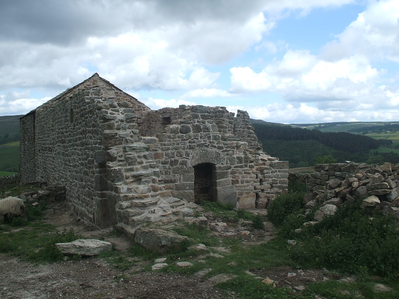
Whitlow III is a derelict range of farmbuildings overlooking the ruins of Whitlow II (NY 64 NE 11), and made up of a bastle 10.8m by 6.4m externally, with a second bastle period building 7.4m long built on to its south end (bastle II), a small outshut on the west and a 19th century barn built onto its north end.
The bastle has a west wall 0.9m thick and end walls of a little over 1m; the east wall, only 0.6m thick, appears to have been entirely rebuilt in the 19th century. The original byre doorway is set in the centre of the south end and has a monolithic lintel cut into a shallow segmental arch. There is a small blocked slit in the centre of the north end (now visible inside the added barn); at first floor level there is an old loop (blocked) in the north end, and a small chamfered window near the south end of the west wall; this has a low rectangular cavity above the internal lintel. The present east wall is of two broad bays, with a central doorway; the ground floor windows reuse the lintels of two-light mullioned windows, and the northern first floor window the sill of a similar opening.
Internally there is a fireplace of late 17th century or early 18th century character, with a simple moulded surround, at the south end of the ground floor, and another of rather later character, with a corbelled out lintel on the north. Towards the south end of the west wall is a shallow recess with a wall cupboard at its rear, and on the north the stub of a removed cross wall; north again is a blocked doorway into the outshut, only the lower courses of which survive. The roof structure is of four irregular bays, with bolted collar beam trusses.
Little survives of the phase II bastle, except for the section of its west wall adjacent to the earlier building. This has a plain square headed doorway. There has been an opposed doorway of similar type in the east wall, of which only the lower part of the south jamb survives; here a field wall has been built on the old foundations; traces of footings mark the south end of the building.
There are also traces of another structure on the east of, and running parallel to, the phase II bastle. Rubble and footings mark its south end and the southern part of its east walls; footings appear to continue north alongside the phase I bastle, and disappear beneath a later garden.
The upper part of the south gable end of the phase I bastle has collapsed within the last ten years and the surviving piece of phase II walling is now leaning outwards (Ryder 1994-5).
Whitlow III is a pair of bastle buildings, with a small outshut and barn additions. The bastle is 10.8m by 6.4m internally, with a second bastle added to this of 7.4m. The original bastle is of two bays, with a central doorway, with flagstone lintels and windows. Recent collapse of the southern gable end is noted, though there is survival of some internal features. Alterations are noted with the outshut. The adjoining barn is noted of roughly-squared stone, with some greatures noted - albeit in some cases blocked - and also in the bastle tradition. Internal features of the house of the 18th century survive. Albeit in a poor condition, and having recently suffered deterioration, Whitlow III is a good example of the Alston Moor farmhouse deriving from a bastle. The addition of a second bastle is noted here, as well as elsewhere, and later this was remodelled in the later 17th or early 18th century. 19th and 20th century alterations are noted. Collapses of the Listed Building can be shown to have occurred between Listing in the 1980s and the present survey, in 1994 and 1995. None of the architectural features have been lost, except a 19th century window, through the collapse affected the fabric (Ryder 2006).
Whitlow bastle was built in about 1600 and may have replaced an older building as there are early foundations a little to the south-east running beneath the present garden wall. Another thick-walled building was added to the south end, but this was not a true bastle despite having thick walls. It is unclear when the bastle was converted into a dwelling with conventional ground floor accommodation. Initially it was thought this occurred around 1700, but further study suggests the ground floor fireplace is re-used and was probably brought down from the first floor in the early 19th century when lead mining brought relative prosperity to the area and the house was modernised. The thick front wall was taken down and rebuilt with new sash windows, and the barn at the north end of the house might have been added at this time. Around 1900, with the decline of the lead industry, the bastle was converted into a byre, which gradually fell into disrepair. In 2007 a scheme of conservation and repair has been undertaken to consolidate the remains (Ryder 2008).
In 2010 the floor level inside the 19th century barn was lowered. This exposed exposed a line of stone slabs running north-south across the building, possibly the edge of a platform for animal stalls and contemporary with the barn (Williams 2010). (Northumberland HER)
Bastle house, now agricultural store and byre. Late C16 or early C17, altered late C17. Rubble, stone dressings, stone slate roof. 2 storeys, 2 wide bays. Central doorway flanked by former 2-light mullioned windows, altered but retaining original heads. Smaller windows above now blocked, that to right retaining sill of 2-light mullioned window. Left return shows original byre entrance with massive jambs and slightly cambered lintel. Rear elevation has small chamfered 1st-floor window with holes for iron bars, to right ruined wall of second bastle-type structure with square-headed doorway. Interior has late C17 fireplace with roll-moulded surround. Later byre to right with 3 slit vents and pitching door, included for group value. (Listed Building Report 1985)
Three such buildings are clustered nearby at Whitlow, barely 300m to the south-east of the fort. One of these, termed 'Whitlow I' by Peter Ryder (1994, 125), is contained within the long range of farm buildings to the south west of the 19th-century farm house. The ruins of the second (Whitlow II) lie some 70m to the north-west of the farm house, and the third (Whitlow III), recently restored and partly roofed, lies a further 30m or so to the north-west. A fourth bastle lies in a more isolated location at the core of the Holymire farm building, part-way between Whitlow III and the fort. The low ruins of Whitlow II and the heavily altered walls of the original Holymire bastle are difficult to date, but the earliest phase at Whitlow I has been assigned with some confidence to around 1600, and that at Whitlow III to the latter part of the 17th century (Ryder 1995, 125; 2006, 4-8; 2008, 12-13). All four of these early buildings have similar dimensions, between 6m and 6.4m in width and from 10m to 10.9m in length, and these proportions are mirrored in many other examples throughout the district (Ryder 1995, 116-125). (Went and Ainsworth)
