GATEHOUSE
The comprehensive gazetteer and bibliography of the medieval castles, fortifications and palaces of England, Wales, the Islands.
 
 
Home
The listings
Other Info
Books
Links
Downloads
Contact
 
Aglionby Platt Home
 
Print Page 
 
Next Record 
Previous Record 
Back to list 

The Gatehouse website record of

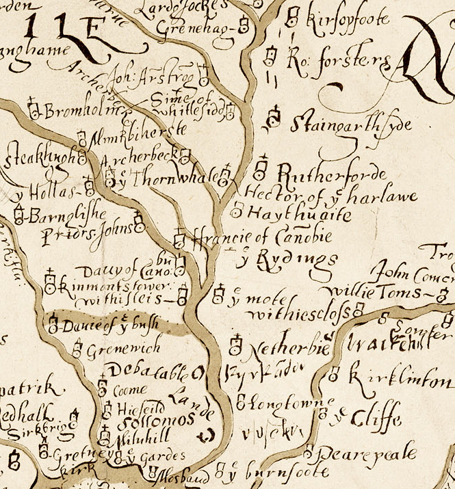
Hector of ye harlawe (Harelaw Tower)

a location shown on a 1590 map of the West Marches of Scotland (The Aglionby Platt)

Also known as, or recorded in historical documents as; Hector of Ye Harlawe; Harlaus; Harlawe

In the civil parish of Canonbie.
In the historic county of Dumfriesshire, Scotland.
Modern Authority of Dumfries And Galloway, Scotland.
1974 county of Dumfries and Galloway, Scotland.

OS Map Grid Reference: NY43497902
Latitude 55.10236° Longitude -2.88709°

The given map reference is suggested as the probable location of Hector of ye harlawe shown on the Aglionby Platt.

There are no visible remains.

The likely form(s) of this building in 1590 are;

  • Tower House (gentry).

A section of the 1590 Aglionby Platt. Image reproduced by permission of the National Library of Scotland
Reproduced by permission of the National Library of Scotland
Description

(NY 4349 7902) Harelaw Tower (NR) (Site of) (OS 6" map (1957))
'Hector of ye Harelawe' tower, seen on a map of 1590, was the stronghold of Hector Armstrong, freebooter, who betrayed the Earl of Northumberland to the Regent Murray in the hope of reward. (Murray was assassinated in 1570 - NT07NW 39). (New Statistical Account (NSA) 1841 (J Donaldson); J and R Hyslop 1912)
No trace of Harlaw Tower survives. (Visited by OS (RD) 18 December 1970)
The tower of 'Hector of ye harlawe' cannot be located. The map of 1590 places it to be in the NE of the junction of the Archer Beck with the River Liddle (NY 419 763), but the NSA places it 'at no great distance' from Penton Linns (NY 431 773) while the OS (6" map, 1957; Name Book 1858) suggest that it stood 700m ENE of Harelawhill farmhouse, in an area now covered by a forestry plantation. (T H B Graham 1914; RCAHMS 1981.)
Listed as tower. (RCAHMS 1997.) (Canmore)

At no great distance from Penton Linns, on the banks of the Liddle, was situated the strong tower of Harelaw, formerly the residence of Hector Armstrong, a famous freebooter. (NSA 1845)

The ruin of Harelaw Tower was standing in 1812 and was near Harelawpike, on the east bank of a little burn, a half mile from its mouth, which empties into the north side of the Liddal about three miles west of Kershope. Two large trees surrounded by smaller ones now mark the spot. At no great distance from Harelaw Tower was Penton Linns. Here the river is contracted by stupendous rocks that rise abruptly on every side and force its waters into a broken narrow channel conducted by a lovely terrace walk along the ledge of a precipice. On the Scottish side of the river one beholds the waters thundering and boiling among the huge rocks that are scattered promiscuously below. (Armstrong 1902)

Harelaw Tower, the abode of Hector Armstrong, and the scene in 1569 of the betrayal, by that laird, of the Earl of Northumberland, was erected on Harelaw hill. The building stood, between the two old sycamore trees growing 74 feet apart in the plantation, at a distance of 20 yards from the high road. Mr. William Armstrong of Calside remembers the site being pointed out to him by the carter who removed the foundation stones. Young Hector, son of the above-named Hector, married Fergus Graham's daughter (Bain, Border Papers., i., p. 122) . (Graham 1914)
Comments

The OS location is certainly not 'on the banks of the Liddle' but is the centre of the several Harelaw place-names in the area. The NSA location is a little away from the modern Harelaw place-names, although not so far as to be impossible. Pont's map of 1607 (in Blaeu 1654), has a a site marked 'Harlaus' at approximately the OS location and another site called 'O. Crukum' at approximately the NSA location. The Roy Military Survey map does no help clarify the possible location. The source in Armstrong (1902) that there were remains in 1812 is unclear but seems to confirm the OS location. Graham also appears to confirm the OS location.
The form of Hector Armstrong's house is not known but he seems to have been a major figure in the Armstrong clan (third only to Seme Armstrong, lord of Mangerton and Lance Armstrong of Whithaugh in the 1583 listing of border riders (Bain p. 121-2) and this seems to be the centre of a large area of arable land so a small tower house of three storeys is, perhaps, more likely than a chamber over byre pelehouse.
The resident householder c. 1590.

Hector Armstrong

Hector of Harelaw, "with the Cuts and the Grieves," seems to have been under English assurance, for he is one of those against whom bills were exhibited by the Scottish commissioners to the lord bishop of Carlisle. In the list of Borderers of 1597, Hector of Harelaw, with the Griefs and Cuts of Harelaw, also figures as an inhabitant of the Debateable Land. It would appear from a spirited invective in the Maitland MS. against the regent and those who delivered up the unfortunate Earl of Northumberland to Elizabeth, that Hector had been guilty of this treachery to redeem the pledge which had been exacted from him for his peaceable demeanor.
" The traitour Eckie of Harelaw,
That says he sould him to redeem his pledge."
The earl, forsaken by his followers, at length reached the house of Hector of Harelaw, with whom he hoped to lie concealed; for Hector had engaged his honor to be true to him, and was under great obligations to this unhappy nobleman. But the faithless wretch betrayed his guest to Murray, the regent of Scotland, by whom he was delivered over to Queen Elizabeth. The writers of that time assure us that Hector, who was rich before, fell shortly into poverty, and became so infamous that "to take Hector's cloak" grew into a proverb, express- ing contempt for one who betrayed his friend. Hector was not alone to blame. "My lord Regent convened with Martin Eliot that he should betray Thomas, Earl of Northumberland, who was fled in Liddesdale out of England for refuge, in this manner: that is to say, the said Martin caused Heckie Armstrong desire my lord of Northumberland to come and speak with him under trust, and caused the said earl believe that, after speaking, if my lord Regent would pursue him, that he and his friends should take plain part with the Earl of Northumberland. And when said earl came Heckie Armstrong to speak the said Martin, he caused certain light-horsemen of my lord Regent's, with others his friends, to lie at await, and when they should see the earl and the said Martin speaking together, that they should come and take the said earl; and so as was devised, so came to pass." ( Diurnal of Occurrents, p. 154.)
Sussex and Sadler wrote that "the Earl of Northumberland was yesterday, at one in the afternoon, delivered by one Hector, of Harlaw wood, of the surname of the Armstrongs, to Alexander Hume, to be carried to the Regent." English and Scottish Popular Ballads.) [online copy
Links to archaeological and architectural databases, mapping and other online resources

Data >
Canmore   County HER        
Maps >
Streetmap   NLS maps   Where's the path   Geology  
Air Photos > 
Bing Maps   Google Maps   Getmapping   Flashearth  
Photos >
Geograph   Flickr   Panoramio      

Sources of information, references and further reading
Most of the sites or buildings recorded in this web site are NOT open to the public and permission to visit a site must always be sought from the landowner or tenant.
It is an offence to disturb a Scheduled Monument without consent. It is a destruction of everyone's heritage to remove archaeological evidence from ANY site without proper recording and reporting.
Don't use metal detectors on historic sites without authorisation.
The information on this web page may be derived from information compiled by and/or copyright of Historic England, RCAHMS (or its successor Historic Environment Scotland), County Historic Environment Records and other individuals and organisations. All the sources given should be consulted to identify the original copyright holder and permission obtained from them before use of the information on this site for commercial purposes.
The author and compiler of Gatehouse does not receive any income from the site and funds it himself. The information within this site is provided freely for educational purposes only.
The bibliography owes much to various bibliographies produced by John Kenyon for the Council for British Archaeology, the Castle Studies Group and others.
Suggestions for finding online and/or hard copies of bibliographical sources can be seen at this link.
Minor archaeological investigations, such as watching brief reports, and some other 'grey' literature is most likely to be held by H.E.R.s but is often poorly referenced and is unlikely to be recorded here, or elsewhere, but some suggestions can be found here.
The possible site or monument is represented on maps as a point location. This is a guide only. It should be noted that OS grid references defines an area, not a point location. In practice this means the actual center of the site or monument may often, but not always, be to the North East of the point shown. Locations derived from OS grid references and from latitude longitiude may differ by a small distance.
Further information on mapping and location can be seen at this link.
Please help to make this as useful a resource as possible by contacting Gatehouse if you see errors, can add information or have suggestions for improvements in functality and design.
Help is acknowledged.
This record created on 10/10/2015 07:21:20; This record last updated on 21/10/2015 09:49:52

Home | Books | Links | Fortifications and Castles | Other Information | Help | Downloads | Author Information | Contact
¤¤¤¤¤