GATEHOUSE
The comprehensive gazetteer and bibliography of the medieval castles, fortifications and palaces of England, Wales, the Islands.
 
 
Home
The listings
Other Info
Books
Links
Downloads
Contact
 
Aglionby Platt Home
 
Print Page 
 
Next Record 
Previous Record 
Back to list 

The Gatehouse website record of

Joh: A strõg: (Ryeleahead)

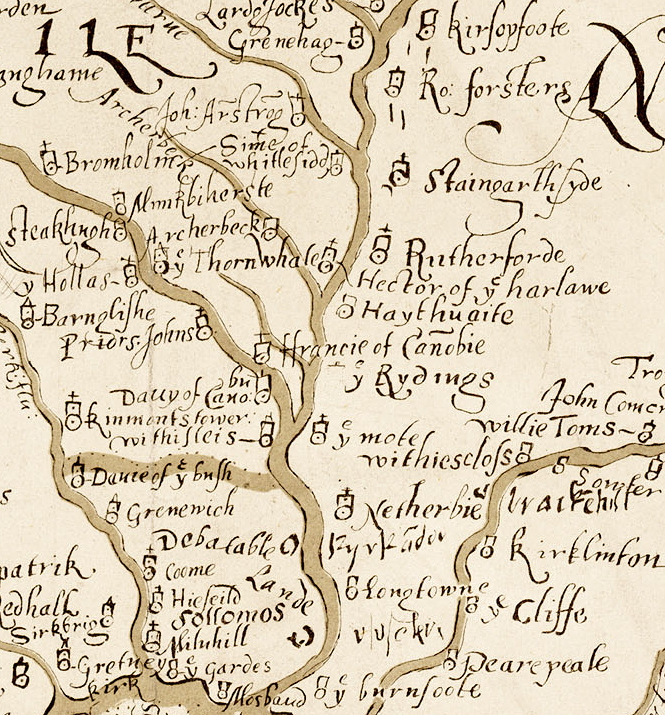
a location shown on a 1590 map of the West Marches of Scotland (The Aglionby Platt)

Also known as, or recorded in historical documents as; Chapel Knowe; Meirburnshead

In the civil parish of Canonbie.
In the historic county of Dumfriesshire, Scotland.
Modern Authority of Dumfries And Galloway, Scotland.
1974 county of Dumfries and Galloway, Scotland.

OS Map Grid Reference: NY45188130
Latitude 55.12304° Longitude -2.86120°

This is certain as the location of Joh: A strõg: shown on the Aglionby Platt.

There are masonry footings remains.

The likely form(s) of this building in 1590 are;

  • Pele House ('bastle').

A section of the 1590 Aglionby Platt. Image reproduced by permission of the National Library of Scotland
Reproduced by permission of the National Library of Scotland
Description

(NY 4517 8130) Chapel (NR) (Remains of) (OS 6" map (1957))
A chapel is said (OSA 1795) to have stood at Chapel Knowe. Only its foundations remained in 1858. (Orig Paroch Scot 1851; Name Book 1858)
NY 4518 8130. The remains of a chapel situated on level ground within a bend in the Muir Burn. Measuring overall 14.2m E-W by 6.8m, the grassed-over walling, 0.8m wide, survives to a maximum height of 0.6m. There is an entrance gap in the S wall. Surveyed at 1:10,000. Visited by OS (TRG) 3 July 1979.
Situated on the E bank of the Muir Burn, 700m WNW of Ryeleahead cottage (NY38SE 24), there are the stone foundations of a rectangular building of lime-mortar construction measuring 12.4m from E to W by 5.1m transversely within walls 0.7m thick. Across the doorway, placed just W of the mid-point of the S side, there is a dressed threshold wrought with a broad chamfer. This is probably the former chapel that the Statistical Account notes at 'Chapel-knowe, on the borders of Canonby' (RCAHMS 1981, visited February 1981; OSA 1791-9; OS 6-inch map, Dumfriesshire, 1st ed. (1862), sheet liv.)
Ryeleahead, Chapel Knowe. Listed as chapel. (RCAHMS 1997)
The remains of this chapel measure 12.3m from E to W by 5.1m transversely within a wall of mortared dressed masonry 0.8m thick and up to 0.9m high. The entrance, on the S, has a chamfered door-surround and the sandstone threshold also has an external chamfer. (LID96 161)
Visited by RCAHMS (SDB) 29 February 1996 (Canmore 67885)

The tower of 'Joh: Armstrong' cannot be located. A map of 1590 notes it to the W of the Muir Burn, at NY c. 444 826. (J and R Hyslop 1912; RCAHMS 1981)
This Armstrong tower is in fact the Puddingburn Tower at NY 4548 8577 (M Robson, Hawick Museum). Visited by OS (MJF) 7 August 1979.
There is no change to the existing record. Information from RCAHMS (JRS), 23 July 1993.
Listed as tower. (RCAHMS 1997) (Canmore 67905)
Comments

A fortified house is marked on the 1590 map in the approximate area of Ryeleahead. This may be the same as Meirburnshead shown on Pont's map of 1607. The remains of the 'Chapel' at Ryeleahead and it general location are entirely consistent with a bastle. Non-conformist chapels often started in domestic houses so it is entirely possible this was a C16 bastle later used as a chapel. However the evidence this was a chapel is solely the OSA account so it may be a misattribution of the remains as a chapel just because it is an East-West orientated building.
Care needs to be taken in interpreting the 1590 map but this doesn't seem to be Puddington Tower. The Armstrong clan was very large with many hundred members of the family in the area many of whom would have been living in modest chamber over byre peel houses.
The given map reference is approximate only. On the first edition 6 inch OS a small enclosure, possibly with a ruined building, is shown at NY44878241 and a small roofed building called Muirburnhead is marked at NY44458178. Noting is visible on the air photo for the first of these (the area is a forestry plantation. The small building survives at the second location. A third enclosure (Rae Gill) is at NY44198234. On the bases of analogue with other sites I would suggest the first of these three as a likely site for a late medieval farmstead and the site of John Armstrong's fortified house (which will, most likely, have been a chamber over byre peel-house of modest dimensions.)
The resident householder c. 1590.

John Armstrong
Links to archaeological and architectural databases, mapping and other online resources

Data >
Canmore   County HER        
Maps >
Streetmap   NLS maps   Where's the path   Geology  
Air Photos > 
Bing Maps   Google Maps   Getmapping   Flashearth  
Photos >
Geograph   Flickr   Panoramio      

Sources of information, references and further reading
Most of the sites or buildings recorded in this web site are NOT open to the public and permission to visit a site must always be sought from the landowner or tenant.
It is an offence to disturb a Scheduled Monument without consent. It is a destruction of everyone's heritage to remove archaeological evidence from ANY site without proper recording and reporting.
Don't use metal detectors on historic sites without authorisation.
The information on this web page may be derived from information compiled by and/or copyright of Historic England, RCAHMS (or its successor Historic Environment Scotland), County Historic Environment Records and other individuals and organisations. All the sources given should be consulted to identify the original copyright holder and permission obtained from them before use of the information on this site for commercial purposes.
The author and compiler of Gatehouse does not receive any income from the site and funds it himself. The information within this site is provided freely for educational purposes only.
The bibliography owes much to various bibliographies produced by John Kenyon for the Council for British Archaeology, the Castle Studies Group and others.
Suggestions for finding online and/or hard copies of bibliographical sources can be seen at this link.
Minor archaeological investigations, such as watching brief reports, and some other 'grey' literature is most likely to be held by H.E.R.s but is often poorly referenced and is unlikely to be recorded here, or elsewhere, but some suggestions can be found here.
The possible site or monument is represented on maps as a point location. This is a guide only. It should be noted that OS grid references defines an area, not a point location. In practice this means the actual center of the site or monument may often, but not always, be to the North East of the point shown. Locations derived from OS grid references and from latitude longitiude may differ by a small distance.
Further information on mapping and location can be seen at this link.
Please help to make this as useful a resource as possible by contacting Gatehouse if you see errors, can add information or have suggestions for improvements in functality and design.
Help is acknowledged.
This record created on 22/07/2015 06:47:11; This record last updated on 17/09/2015 11:28:09

Home | Books | Links | Fortifications and Castles | Other Information | Help | Downloads | Author Information | Contact
¤¤¤¤¤