GATEHOUSE
The comprehensive gazetteer and bibliography of the medieval castles, fortifications and palaces of England, Wales, the Islands.
 
 
Home
The listings
Other Info
Books
Links
Downloads
Contact
 
Aglionby Platt Home
 
Print Page 
 
Next Record 
Previous Record 
Back to list 

The Gatehouse website record of

Pickeringhaw (Prickinghaugh)

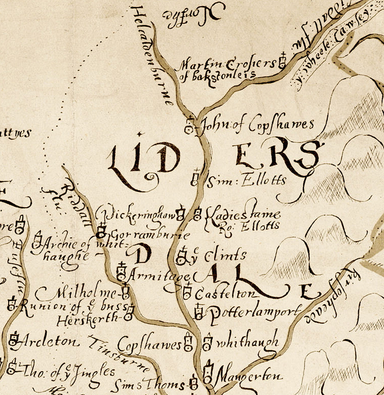
a location shown on a 1590 map of the West Marches of Scotland (The Aglionby Platt)

Also known as, or recorded in historical documents as; Pricking Haugh; Breaken

In the civil parish of Castleton.
In the historic county of Roxburghshire, Scotland.
Modern Authority of Scottish Borders, Scotland.
1974 county of Borders, Scotland.

OS Map Grid Reference: NY54389432
Latitude 55.24104° Longitude -2.71882°

Prickinghaugh has been suggested as a location on the Aglionby Platt although is doubtful that it was such.

There are no visible remains.

The likely form(s) of this building in 1590 are;

  • Tower House (gentry).

A section of the 1590 Aglionby Platt. Image reproduced by permission of the National Library of Scotland
Reproduced by permission of the National Library of Scotland
Description

Only the foundations remain of a tower which stood at Prickinghaugh (cf NY59SW 7 and NY59SW 13 ). (OSA 1795)
Pont's map of Liddesdale (1608) shows Prickinghaugh on a tributary called Todscleuch (Todshaw Sike: name 536 944) which joined the liddle Water from the right. However, a map dated 1590, now in the British Museum, indicates "Pickeringhaw" with a tower symbol on the right bank of the Liddle Water below the junction of Helcaldenburne (NY 5800 9885). Also, a building named "Prickinghaugh" appear on Gordon's map at approximately NY 541 940. (A Jeffrey 1864; R Gordon 1650 (MS. map of Eskdale and Liddesdale in NLS))
Prickinghaugh Tower is the correct name for that published as Breaken at NY 5438 9432 (see NY59SW 7); the general location is not disputed. On perambulation of the above alternative sites no significant features were noted. That placed further north along the Liddle Water almost certainly refers to an entirely different site. (Visited by OS (JRL) 27 July 1979)
See also NY59SW 7. (Canmore 68037)

(Approx NY 547 944) The strong fort of Robert Elliot stood on the left bank of Liddel Water and adjacent to the house of Haggishaugh (marked on Stobie's map of Roxburghshire, 1770, at Larriston). When its foundations were dug up about sixty years ago, the workmen discovered what had been a large oven also an 18 lb cannon-ball. A map in the British Museum dated 1590 marks a tower symbol in this area, with the name "Robert Elliot, Ladiestane". All the Border Elliots are descended from this Robert Elliot. (cf NY59SW 7 and NY59SW 8 ). (A Jeffrey 1864) (Canmore 68008)

(NY 5438 9432) Breaken Tower (NR) (Site of) (OS 6" map (1957))
The Breaken or Pricking Haugh Tower, now entirely demolished, stood near Larriston (cf NY59SW 8 and NY59SW 13 ). (J Hardy 1890)
This spot was pointed out by James Elliot of Middleholm as the site of the Breaken Tower, property of the Elliots. (Name Book 1858)
Dr Robson (Hawick Museum) confirms that Breaken and Prickinghaugh Tower are one and the same and that the former name is just a shortened corruption of the latter. He also confirms the general location, although an 1816 map of Liddesdale held at Wilton lodge Museum shows the site on the opposite bend of the river in area NY 5435 9423. The tower was entirely demolished for wall building material in 1792.
The OS published site falls in a featureless and gently undulating pasture field; nothing significant was noted on the opposite bank of the Liddle Water. Visited by OS (JRL) 27 July 1979
Site confirmed by 'divining'. Information from letter and plan from A Elliot, Providence Cottage, Westgate, Bishop Auckland, Co Durham 7 August 1986. (Canmore 68036)
Comments

This confabulation between this site and Larriston.
The 1590 map probably records fortified house of border reviers but was probably made by someone with only general knowledge of the local geography and who was probably working from second-hand accounts. It shows two houses called 'Pickeringhaw' and 'Ladiesstaine Ro: Ellotts' on opposite banks of the Liddel Water.
The Pont map of 1608 (published in Blaeu in 1654) shows habitations (not just towers) and, while Pont probably understood the geography somewhat better is still a rough map. It shows, with a somewhat large symbol than usual, a place called 'Prickinghauch' north of the Liddel Water and opposite a 'N. Laristoun' and further upstream a 'Zaristounn'.
The Roy map of c. 1750 shows two residences, close to each other, on the south side of the Liddel Water, the downstream site is unnamed the upstream site is labelled 'Hagygs haugh'.
The Liddel Water does sit in a 'U' shaped valley and has changed course within that valley over time. I suspect that in the C16/C17 the course of the Liddel Water was between the two sites.
On this bases I suggest the 1590 house called Pickeringhaw was the Breaken Tower site and this was a small tower house, which accounts for it's somewhat different presentation on the Pont map.
The finds reported by Jeffrey relate to this site which he, in my view, erroneously equated with the 'Ladiesstaine Ro: Ellotts' site.
Links to archaeological and architectural databases, mapping and other online resources

Data >
Canmore            
Maps >
Streetmap   NLS maps   Where's the path   Geology  
Air Photos > 
Bing Maps   Google Maps   Getmapping   Flashearth  
Photos >
Geograph   Flickr   Panoramio      

Sources of information, references and further reading
Most of the sites or buildings recorded in this web site are NOT open to the public and permission to visit a site must always be sought from the landowner or tenant.
It is an offence to disturb a Scheduled Monument without consent. It is a destruction of everyone's heritage to remove archaeological evidence from ANY site without proper recording and reporting.
Don't use metal detectors on historic sites without authorisation.
The information on this web page may be derived from information compiled by and/or copyright of Historic England, RCAHMS (or its successor Historic Environment Scotland), County Historic Environment Records and other individuals and organisations. All the sources given should be consulted to identify the original copyright holder and permission obtained from them before use of the information on this site for commercial purposes.
The author and compiler of Gatehouse does not receive any income from the site and funds it himself. The information within this site is provided freely for educational purposes only.
The bibliography owes much to various bibliographies produced by John Kenyon for the Council for British Archaeology, the Castle Studies Group and others.
Suggestions for finding online and/or hard copies of bibliographical sources can be seen at this link.
Minor archaeological investigations, such as watching brief reports, and some other 'grey' literature is most likely to be held by H.E.R.s but is often poorly referenced and is unlikely to be recorded here, or elsewhere, but some suggestions can be found here.
The possible site or monument is represented on maps as a point location. This is a guide only. It should be noted that OS grid references defines an area, not a point location. In practice this means the actual center of the site or monument may often, but not always, be to the North East of the point shown. Locations derived from OS grid references and from latitude longitiude may differ by a small distance.
Further information on mapping and location can be seen at this link.
Please help to make this as useful a resource as possible by contacting Gatehouse if you see errors, can add information or have suggestions for improvements in functality and design.
Help is acknowledged.
This record created on 22/07/2015 06:57:24; This record last updated on 17/09/2015 11:36:57

Home | Books | Links | Fortifications and Castles | Other Information | Help | Downloads | Author Information | Contact
¤¤¤¤¤