GATEHOUSE
The comprehensive gazetteer and bibliography of the medieval castles, fortifications and palaces of England, Wales, the Islands.
 
 
Home
The listings
Other Info
Books
Links
Downloads
Contact
 
Aglionby Platt Home
 
Print Page 
 
Next Record 
Previous Record 
Back to list 

The Gatehouse website record of

ye Cast of Hoddamsteanes (Hoddam Castle)

a location shown on a 1590 map of the West Marches of Scotland (The Aglionby Platt)

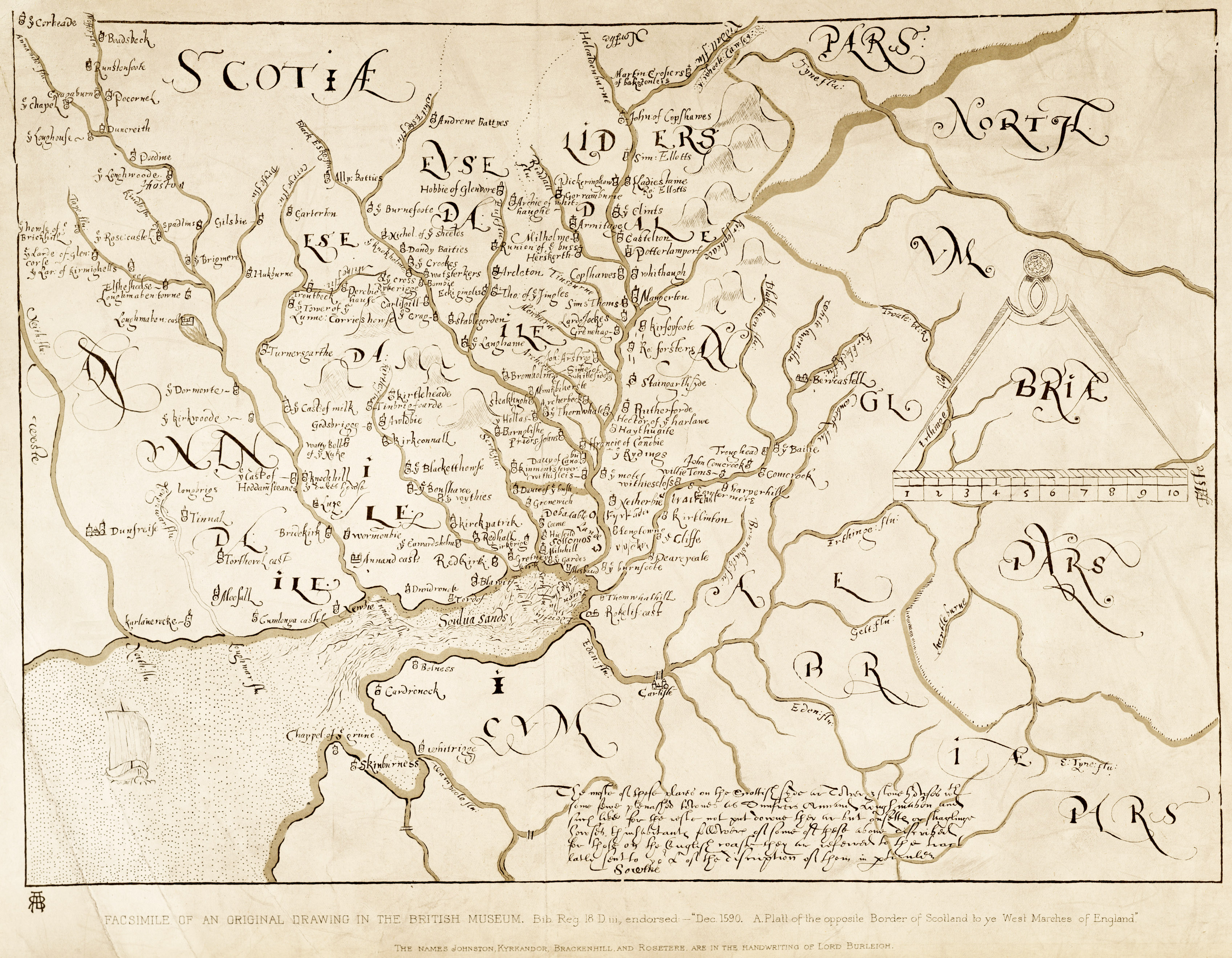
Also known as, or recorded in historical documents as; Hoddom Castle

In the civil parish of Cummertrees.
In the historic county of Dumfriesshire, Scotland.
Modern Authority of Dumfries and Galloway, Scotland.
1974 county of Dumfries and Galloway, Scotland.

OS Map Grid Reference: NY15607296
Latitude 55.04405° Longitude -3.32222°

This is certain as the location of ye Cast of Hoddamsteanes shown on the Aglionby Platt.

There are major building remains.

The likely form(s) of this building in 1590 are;

  • Tower House (baronial).

A section of the 1590 Aglionby Platt. Image reproduced by permission of the National Library of Scotland
Reproduced by permission of the National Library of Scotland
Description

Hoddom or Hoddam Castle: When described in 1965, this tower was derelict, and the modern mansion (of the same name) attached was being demolished. It occupies a strong site, defended by a moat, part of which remained to the S. Built in the 16th century, probably incorporating 15th century work, the building is L-shaped, the main block rising four storeys to the parapet, with a garret above, while the stair wing continues for another two storeys. (See also NY17SE 3 and NY17SE 12 ); RCAHMS 1920, visited 1915; N Tranter 1965)
Hoddom Castle is as described. The portion of moat to the SE is 5.0m deep. Visited by OS (RD) 23 October 1967
No change to previous field report. Visited by OS (IA) 22 February 1973.
Hoddam belonged to the Herries family of knights who served the Bruces, and then passed to the Carruthers. The massive L-plan tower rising above the River Annan was built by John Maxwell, Lord Herries, soon after he obtained possession in the mid-16th century. It was regarded as a place of some strength but in 1568 an indifferent garrison surrendered the castle to the Regent Moray after a one day siege. He handed it over to Douglas of Drumlanrig to serve as headquarters for the office of Warden of the Scottish West March, but in 1569 Hoddom was recaptured by forces loyal to Queen Mary. In 1570 the English commander Lord Scroop captured and blew up the tower. It was restored, and further remodelling was carried out after Sir Richard Murray obtained Hoddam from the 6th Lord Herries. It passed to the Earl of Southesk in 1653 and to the Sharp family in 1690, and was later held by the Brooks.
Hoddom Castle now lies derelict on one side of a caravan park. Demolition of a lower later wing has left a scar on the south end wall of the main block, which measures 15.5m by 11m and has four storeys and an attic surrounded by a wall-walk 15.3m above ground. The ornamental coursing carrying the parapet and round bartizans continues round a wing 8.7m wide and 22m high. The wing has two full stories above the coursing and ends in a flat roof with an open bartizan at the SE corner, conical roofed bartizans on the W corners and a higher staircase turret on the NE. Below the foot of the stair is a prison. The entrance doorway has a segmental arch and a bold quirked edge roll moulding with a fillet. the label above the doorway is a big cable with mutilated knotted stops.
There is a much-altered 17th-century courtyard wall on the S and E. Much of the dry moat has now been filled in. (M Salter 1993)
On the second floor, beside a remodelled fireplace in the SSE wall, and not noted in the published Inventory description, there is an aumbry which still retains its original 16th-century oak frame, door and iron fittings. The frame of the door (which comprises four members and a muntin) is morticed, and the tenons are pinned in place with dowels; the two panels are joined by a tongue-and-groove and wrought on the arris with a mitred chamfer. The wrought iron tee hinges and the leaded clasps retaining the butted frame have butterfly terminals while the arms of the two hinges bear mid-length rosette expansions. Visited by RCAHMS (IMS), 15 October 1993.
Listed as tower. (RCAHMS 1997) (Canmore)

Part of a large asymmetrical mansion, nucleus a fine L-plan 16th century tower house, main (S) courtyard W walls, gateway and turrets largely 17th century; circa 1826 additions by William Burn to S and to W of tower largely demolished circa 1970; extensive neo-Jacobean 1, 2 and 3-storey additions to N and to W built 1878-1891 (dated throughout), some, at least, by Wardrop and Anderson circa 1886; additions mainly comprising open stable court, service ranges to N beyond: now run as a holiday centre for caravan park; tower is abandoned. TOWER: various alterations particularly at upper level and to interior; fantastic skyline probably 18th century. 4 storeys with attic and corbelled parapets, jamb corbelled 2 storeys higher with conical roofed bartizans and 19th century cap-house; parapet encloses slated and crow-stepped-gabled main roof. Massively thick red ashlar walls, openings mostly roll-moulded: deep raggles and door slappings where later ranges abutted. Rope-moulded doorway in re-entrant angle; wide horizontal gunports at ground; some upper floor windows enlarged. (Historic Scotland)
Hoddom has passed through the hands of the Earl of Annandale (17th century), the Earl of Southesk (1653), John Sharpe, Dumfries burgess (1690), Charles Kirkpatrick Sharpe (1769), Lt General Matthew Sharpe (early 19th century), and Edward Brook, Huddersfield mill owner (1877). (Buildings at Risk Register)
The resident householder c. 1590.

Sir Richard Murray
Links to archaeological and architectural databases, mapping and other online resources

Data >
Canmore   County HER        
Maps >
Streetmap   NLS maps   Where's the path   Geology  
Air Photos > 
Bing Maps   Google Maps   Getmapping   Flashearth  
Photos >
Geograph   Flickr   Panoramio      

Sources of information, references and further reading
Most of the sites or buildings recorded in this web site are NOT open to the public and permission to visit a site must always be sought from the landowner or tenant.
It is an offence to disturb a Scheduled Monument without consent. It is a destruction of everyone's heritage to remove archaeological evidence from ANY site without proper recording and reporting.
Don't use metal detectors on historic sites without authorisation.
The information on this web page may be derived from information compiled by and/or copyright of Historic England, RCAHMS (or its successor Historic Environment Scotland), County Historic Environment Records and other individuals and organisations. All the sources given should be consulted to identify the original copyright holder and permission obtained from them before use of the information on this site for commercial purposes.
The author and compiler of Gatehouse does not receive any income from the site and funds it himself. The information within this site is provided freely for educational purposes only.
The bibliography owes much to various bibliographies produced by John Kenyon for the Council for British Archaeology, the Castle Studies Group and others.
Suggestions for finding online and/or hard copies of bibliographical sources can be seen at this link.
Minor archaeological investigations, such as watching brief reports, and some other 'grey' literature is most likely to be held by H.E.R.s but is often poorly referenced and is unlikely to be recorded here, or elsewhere, but some suggestions can be found here.
The possible site or monument is represented on maps as a point location. This is a guide only. It should be noted that OS grid references defines an area, not a point location. In practice this means the actual center of the site or monument may often, but not always, be to the North East of the point shown. Locations derived from OS grid references and from latitude longitiude may differ by a small distance.
Further information on mapping and location can be seen at this link.
Please help to make this as useful a resource as possible by contacting Gatehouse if you see errors, can add information or have suggestions for improvements in functality and design.
Help is acknowledged.
This record created on 20/07/2015 10:03:02; This record last updated on 17/09/2015 10:44:53

Home | Books | Links | Fortifications and Castles | Other Information | Help | Downloads | Author Information | Contact
¤¤¤¤¤