GATEHOUSE
The comprehensive gazetteer and bibliography of the medieval castles, fortifications and palaces of England, Wales, the Islands.
 
 
Home
The listings
Other Info
Books
Links
Downloads
Contact
 
Aglionby Platt Home
 
Print Page 
 
Next Record 
Previous Record 
Back to list 

The Gatehouse website record of

ye Blacketthowse (Blacket House)

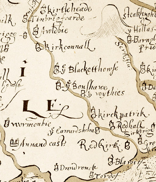
a location shown on a 1590 map of the West Marches of Scotland (The Aglionby Platt)

Also known as, or recorded in historical documents as; Blacket Tower; Blackwood Tower; Blackethouse; Blackwoodhouse

In the civil parish of Middlebie.
In the historic county of Dumfriesshire, Scotland.
Modern Authority of Dumfries And Galloway, Scotland.
1974 county of Dumfries and Galloway, Scotland.

OS Map Grid Reference: NY24337436
Latitude 55.05802° Longitude -3.18603°

This is certain as the location of ye Blacketthowse shown on the Aglionby Platt.

There are masonry footings remains.

This site is a scheduled monument protected by law.

The likely form(s) of this building in 1590 are;

  • Tower House (gentry)
    Pele House ('bastle').

A section of the 1590 Aglionby Platt. Image reproduced by permission of the National Library of Scotland
Reproduced by permission of the National Library of Scotland
Description

For successor and present country house (NY 2432 7432), see NY27SW 24.
(NY 24338 74369) Blacket House (NR) (Remains of) (OS 25" map (1899))
A ruined tower, 21 ft x 15 ft 6 ins, with a projecting staircase wing 10 ft 6ins by 12 ft 6 in at Blacket or Blackwood House, near the modern house of the same name. On the lintel of the short wing is the date 1663. Foundations of NE and SE walls of the main block each with indications of a narrow short hole, remained in 1912. Blackethouse is mentioned in 1584. (RCAHMS 1920).
Generally as described and planned by RCAHMS except that the NE and SE walls stand to roof height. On the inside lintel of the short wing is the inscription 17 GB IK 14, possibly suggesting an addition or alteration to the earlier structure. Name 'Blacket House' confirmed. (Visited by OS (RD) 19 October 1967)
No change to previous field report. (Visited by OS (IA) 21 February 1973)
Listed as tower. (RCAHMS 1997) (Canmore)

The monument comprises Blacket House Tower, also known as Blackwood House, which is of medieval date, visible as an upstanding ruin. The monument is situated on a plateau above the W bank of the Kirtle Water at about 80m OD.
John Bell of Blackwoodhouse is on record in 1459 and 1465, the Bell family having settled near Middlebie at the beginning of the 15th century. Blacket House Tower appears to date from the second half of the 16th century; William 'Red-Cloak' Bell is documented as being of 'Blacathous' in 1583/4. Its situation provides commanding views along the Kirtle Water from Old Kirkconnel to Wyseby and Bonshaw, which allowed the Bells to keep a watchful eye on their Irving and Graham neighbours. The tower is depicted on the Aglionby's Platte as 'Ye Blacketthowse' in 1590, and on the Pont map as 'Black-wood hous' in c.1595-96.
Evidence suggests that the building was originally rectangular in plan, comprising three storeys and a garret; the ground floor and a substantial portion of the S wall appear to date from the original construction. The walls are 1.2m thick and the ground floor was most probably vaulted. Atypically, the entrance appears to have been located at the SW end of the SE wall rather than as part of the wheelstair at the E corner.
The stair wing is likely to date to the early 17th century, forming an L-plan and superseding the original entrance with an unusual double rebate for an iron yett and wooden door and also a substantial drawbar slot. Part of a parapet remains, but it is unclear if it followed the form of the 16th century tower. One of its openings on its SE elevation was probably enlarged at this time. Some linear features are visible beneath the lawn to the SW which may indicate the presence of further ranges.
It is likely that the tower was enlarged in 1663: a lintel bearing this date, with the initials IB and II for John Bell and Jean Irving, was later re-used. Only part of the S wall of the extension remains, set at an angle to the W corner. Further work appears to have taken place in the early 18th century given the existence of a 1714 datestone. The tower was sold in 1775 and changed hands on a number of occasions subsequently. When Blacket House was built to its immediate SW in 1835, the tower was described as being 'ruinous'. It was then converted into a folly and the datestones built into a 'doorway' situated to the W of the tower. Later, pigeonholes were added to the stair wing to create a doocot, whilst a study conversion dates to about 1950.
The area proposed for scheduling comprises the remains described and an area around them within which related material may be expected to survive. It is irregular in plan with maximum dimensions of 67.5m WNW-ESE and 64.5m NW-SE, as marked in red on the accompanying map. The NE side is defined by the cliff edge, the SW side and SW part of the SE side by the gravel driveway and the NW side by a slight boundary feature in the lawn. The surfaces of all paths, to a depth of 300mm, is excluded from the scheduling to allow for routine maintenance. (Scheduling Report)
Comments

Although the current ruinous remains are of a three storey building with garret of the original C16 building only a basement really survives and it is not really clear if this was a tower of several storeys or a peel of a chamber over byre type.
Has a water chute over the entrance.
Links to archaeological and architectural databases, mapping and other online resources

Data >
Canmore   County HER   Scheduling    
Maps >
Streetmap   NLS maps   Where's the path   Geology  
Air Photos > 
Bing Maps   Google Maps   Getmapping   Flashearth  
Photos >
Geograph   Flickr   Panoramio      

Sources of information, references and further reading
Most of the sites or buildings recorded in this web site are NOT open to the public and permission to visit a site must always be sought from the landowner or tenant.
It is an offence to disturb a Scheduled Monument without consent. It is a destruction of everyone's heritage to remove archaeological evidence from ANY site without proper recording and reporting.
Don't use metal detectors on historic sites without authorisation.
The information on this web page may be derived from information compiled by and/or copyright of Historic England, RCAHMS (or its successor Historic Environment Scotland), County Historic Environment Records and other individuals and organisations. All the sources given should be consulted to identify the original copyright holder and permission obtained from them before use of the information on this site for commercial purposes.
The author and compiler of Gatehouse does not receive any income from the site and funds it himself. The information within this site is provided freely for educational purposes only.
The bibliography owes much to various bibliographies produced by John Kenyon for the Council for British Archaeology, the Castle Studies Group and others.
Suggestions for finding online and/or hard copies of bibliographical sources can be seen at this link.
Minor archaeological investigations, such as watching brief reports, and some other 'grey' literature is most likely to be held by H.E.R.s but is often poorly referenced and is unlikely to be recorded here, or elsewhere, but some suggestions can be found here.
The possible site or monument is represented on maps as a point location. This is a guide only. It should be noted that OS grid references defines an area, not a point location. In practice this means the actual center of the site or monument may often, but not always, be to the North East of the point shown. Locations derived from OS grid references and from latitude longitiude may differ by a small distance.
Further information on mapping and location can be seen at this link.
Please help to make this as useful a resource as possible by contacting Gatehouse if you see errors, can add information or have suggestions for improvements in functality and design.
Help is acknowledged.
This record created on 02/08/2015 09:37:25; This record last updated on 17/09/2015 10:52:50

Home | Books | Links | Fortifications and Castles | Other Information | Help | Downloads | Author Information | Contact
¤¤¤¤¤