GATEHOUSE
The comprehensive gazetteer and bibliography of the medieval castles, fortifications and palaces of England, Wales, the Islands.
 
 
Home
The listings
Other Info
Books
Links
Downloads
Contact
 
Aglionby Platt Home
 
Print Page 
 
Next Record 
Previous Record 
Back to list 

The Gatehouse website record of

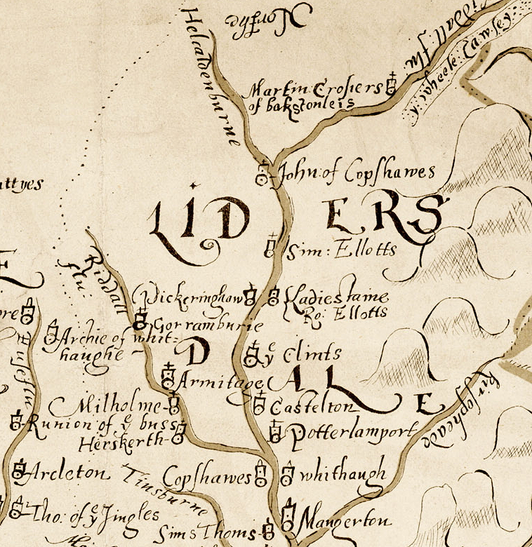
y wheele Cawsey (Wheel Causeway)

a location shown on a 1590 map of the West Marches of Scotland (The Aglionby Platt)

Also known as, or recorded in historical documents as; Wheel Rig; While Caussye; Wheele Caussye; Whele Causay

In the civil parish of Castelton; Southdean.
In the historic county of Roxburghshire, Scotland.
Modern Authority of Scottish Borders, Scotland.
1974 county of Borders, Scotland.

OS Map Grid Reference: NY607979
Latitude 55.27426° Longitude -2.61984°

This is certain as the location of y wheele Cawsey shown on the Aglionby Platt.

There are earthwork remains.

This site is a scheduled monument protected by law.

The likely form(s) of this building in 1590 are;

  • Other.

A section of the 1590 Aglionby Platt. Image reproduced by permission of the National Library of Scotland
Reproduced by permission of the National Library of Scotland
Description

Old Road (probably in use during the 13th Century.)
On the S slope of Wardmoor Hill (NT 6058 0628) two hollow tracks can be followed, one on each side of the foundations of a demolished turf dyke and thence for the rest of the distance there is nothing to remark beyond further hollow tracks, often poorly defined, and stretches of grassland lightly scored by the passage of animals. Between the heads of the Wolfehopelee Burn (NT 6058 0719) and Battling Sike (NT 6074 0724), and before splitting up and entering the improved lands, the road passes through a linear earthwork (NT60NW 13) (at NT 6068 0719) in two main tracks.
Alternative Northward extensions, Southdean and Jedburgh Parishes:
From NT 6068 0719 the Wheel Causeway splits into at least three branches, and as these immediately enter enclosed land, and have been subject to agricultural use in recent times as well, no doubt, as to droving, no conclusions can safely be drawn about this part of the Causeway proper in its original form.
One of the three branches leads "through trig. station 1125, along the E flank of Wolfelee Hill (NT 5971 0847), and thence swings NW to join the highway at Cleuch Head (NT 5938 1008). On the first edition OS 6 inch (Roxburgh 25 SW) the branch mentioned above has been recorded as a part of the Wheel Causeway proper as it follows the approximate line as published on the OS map. Information from OD (DT) 1 Nov 1957. (RCAHMS 1956)
NT 608 061 to NT 609 055 Scheduled
From NT 609 050 the Causeway runs northwards as a mutilated hollow way through the Wauchope Forest to the sheepfold at NT 609 054 where it emerges into open moorland. On the S slope of Wardmoor Hill two hollow tracks can be followed on each side of a demolished turf dyke. For the rest of the distance to NT 6068 0719 the road is represented by hollow tracks, often poorly defined. At NT 6068 0719 the Causeway is said to divide into three branches:
1) the Causeway itself leads through NT 605 075 and along the E flank of Wolfelee Hill to NT 6000 0919 where it leaves this map sheet. There is no trace of the road between NT 606 072 and NT 605 075.
2) A branch runs northwards through a plantation to NT 6097 0699 and from there it can be traced as a curving hollow way c.6m broad to NT 607 078. It then continues northwards as a slight terrace for about 250m when all traces are lost in the vicinity of a quarry. No traces could be found beyond this point.
3) Another branch leads past Highlee Hill (NT 616 079) and Lustruther farm (NT 6241 0922) to the road junction at NT 6277 0934. No traces could be found beyond this point.
Two further branches of the Causeway are said to run northwards from Jedhead (NT 6243 0500), one on either side of the Jed Water. One follows the course past Westshiels (NT 6227 0645) to Dykeraw Tower (NT 6283 0906). No traces could be found beyond this point. The other follows the course over Millmoor Rig (NT 632 067) and leaves the map sheet at NT 699 094. Information from OS (WDJ) 5 Oct 1960. (Canmore)
Comments

Medieval ridge road running from, at least Deadwater in Northumberland north marked on the 1590 map.
The given map reference is for the point the causeway enters into Scotland.
Links to archaeological and architectural databases, mapping and other online resources

Data >
Canmore       Scheduling    
Maps >
Streetmap   NLS maps   Where's the path   Geology  
Air Photos > 
Bing Maps   Google Maps   Getmapping   Flashearth  
Photos >
Geograph   Flickr   Panoramio      

Sources of information, references and further reading
Most of the sites or buildings recorded in this web site are NOT open to the public and permission to visit a site must always be sought from the landowner or tenant.
It is an offence to disturb a Scheduled Monument without consent. It is a destruction of everyone's heritage to remove archaeological evidence from ANY site without proper recording and reporting.
Don't use metal detectors on historic sites without authorisation.
The information on this web page may be derived from information compiled by and/or copyright of Historic England, RCAHMS (or its successor Historic Environment Scotland), County Historic Environment Records and other individuals and organisations. All the sources given should be consulted to identify the original copyright holder and permission obtained from them before use of the information on this site for commercial purposes.
The author and compiler of Gatehouse does not receive any income from the site and funds it himself. The information within this site is provided freely for educational purposes only.
The bibliography owes much to various bibliographies produced by John Kenyon for the Council for British Archaeology, the Castle Studies Group and others.
Suggestions for finding online and/or hard copies of bibliographical sources can be seen at this link.
Minor archaeological investigations, such as watching brief reports, and some other 'grey' literature is most likely to be held by H.E.R.s but is often poorly referenced and is unlikely to be recorded here, or elsewhere, but some suggestions can be found here.
The possible site or monument is represented on maps as a point location. This is a guide only. It should be noted that OS grid references defines an area, not a point location. In practice this means the actual center of the site or monument may often, but not always, be to the North East of the point shown. Locations derived from OS grid references and from latitude longitiude may differ by a small distance.
Further information on mapping and location can be seen at this link.
Please help to make this as useful a resource as possible by contacting Gatehouse if you see errors, can add information or have suggestions for improvements in functality and design.
Help is acknowledged.
This record created on 06/08/2015 06:09:11; This record last updated on 17/09/2015 11:38:23

Home | Books | Links | Fortifications and Castles | Other Information | Help | Downloads | Author Information | Contact
¤¤¤¤¤